Town plans of Exeter
Based on a workshop given in Exeter Guildhall in September 2006 during an exhibition of Exeter maps prepared by Dr Todd Gray. [Return to index page].
Exeter exemplifies the pitfalls that beset those using maps to trace the development of urban communities. As in the case of county maps of Devon and elsewhere, plans of Exeter and other major towns have in the past been the result of a few major surveys which have then been copied repeatedly. In Exeter, before the Ordnance Survey, there have been only four surveys that have had a major influence on printed plans:
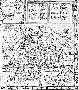
1. 1587. John Hooker. Isca Danmoniorum
The full title is: Isca Danmoniorum Britan<n>ice Kaier Penhuelgorte: Saxonice Monketon: Latine Exonia: Anglice Exeancestre vel Exestre at nunc vulgo Exeter: urbs pera<n>tiqua, et emporium celeberrimum. - [London?] : Opera et impensis Joannis Hokeri generosi ac huius civitatis quaestoris hanc tabella<m> sculpsit Remigius Hogenberg , 1587. - 355x510mm. STC 24886.3.
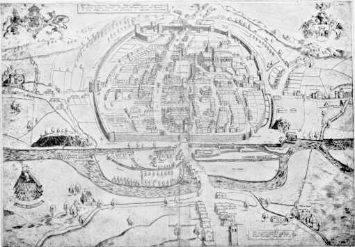
Exeter is among the earliest provincial towns in England to boast a published map, although, as is normal in the Tudor period, it was more of the nature of a bird's eye view. We are indebted for this to John Hooker, the first Chamblerlain of Exeter, who commissioned a number of works relating to Exeter from London publishers, mostly compiled by himself, and which were often intended as new years' gifts. His map of Exeter, commissioned in London from the engraver Flemish engraver Remigius Hogenberg, was probably inspired by the copperplate map of London produced in about 1559, probably engraved by Franciscus Hogenberg and copied by Ralph Agas in 1563. It survives in three states:
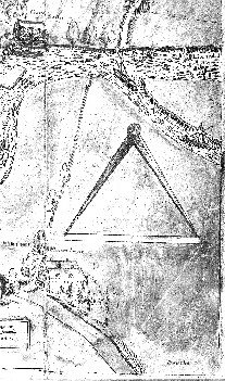
State A: Pair of dividers in lower right corner. British Library.
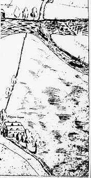
State B: Dividers erased. One copy with Dymond family of Chagford.
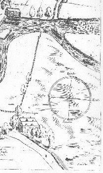
State C: Compass rose added in lower right corner, St. Leonard area re-engraved, church repositioned 4cm higher. Copy in Exeter Guildhall.
This map formed the basis of all printed maps of Exeter for more than a century:
1611. Speed, John.
A plan derived from state A or B of Hooker was incorporated into the well-known county map of Devon produced by John Speed (1552-1629). This was probably prepared in 1610 and was first issued in the Theatre of the empire of Great Britaine in 1611 (Batten and Bennet 6). It was reissued, the Exeter area of the plate unchanged, except for the addition of a few scratches, in at least ten different states of the main plate until 1756.
1689. Lea, Philip.

Speed's map was closely copied in 1689 for Philip Lea's All the shires of England and Wales (Batten & Bennet 19) Lea had acquired most of the Saxton county plates for this work but that for Devon was missing. He replaced it with a close copy of Speed's plate of 1611.
1618. Braun & Hogenberg. Civitas Exoniae (vulgo Excester).
This was the source for most later copies of Hooker's plan and it is itself the largest and most detailed of the derived plates. Copied from state A or B, of Hooker, it first appeared in volume six of the extensive publication Civitates orbis terrarum, published in Cologne and was issued in several later publications, notably by Jansson in Amsterdam in 1660 in Illustriorum principiumque urbium septentrionalium Europae tabulae. It was also re-engraved for Samuel and Daniel Lyson's Magna Britannia in 1822. Other smaller derived plates are:
1650. Merian, Matthias. Exonia, Excester.
This appeared in a collection entitled Plans of 17 towns of Great Britain and Ireland and the plate appears to have been reused in 1690 in J.C.Beer's Das neu-beharnischte Grosz-Britannien, published in Nuremberg.
1661. Hermannides, Rutgerus.Exonia. Excester.
This appeared in Britannia magna, published in Amsterdam. The plate was revised in 1729 for La galérie agréable du monde, published by Pierre Vander AA, with the addition of a decorative top border which inclued a key to seven numbered sites. Other sites were named on the map itself. The whole was then printed within a trompe l'oeil engraved frame which doubled the dimensions of the print.
1677. Izacke, Richard. A mapp of the city of Exeter.
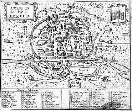
This appeared in Izacke's Antiquities of the city of Exeter, which was published in London by Richard Marriott. This plan was undoubtedly copied from Speed, as the same numbering is used for the list of buildings. However little attempt seems to have been made at checking on the ground as the crane by the quay has been transformed into a windmill.
1700. Meisner, Daniel. Excester in Engellandt.
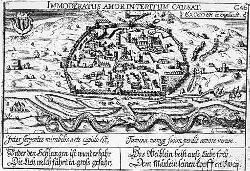
This is perhaps the most extraordinary of the maps derived from Hooker. It appeared in Libellus novus politicus emblematicus civitatum and Exeter is used to point the moral of the dangers of excessive lust. The Latin and German texts explain the serpents shown on the plate where the female is supposed to bite off the head of the male in her passion.
Ogilby, John. The sheets covering Devon in Britannia by John Ogilby (1600-1676) represented the first attempt to depict Exeter in a style more recognisably like today's mapping. However the scale of these strip maps of the major roads was only one inch to a mile and the detail is insufficient to have had a major impact on the published mapping of the city.
2. 1709. Coles, Joseph. A true plan of the city of Excester Anno Domini MDCCIX.
The title continues: Ichd: Fairlove surveyd Io: Coles sculp: - [Exeter] : Sold by Edward Score bookseller over agst: the Guildhall , [1709]. - 1 sheet ; 1°.

1723. Nichols, Sutton Nichols. A true plan of the city of Excester.

1723. Stukeley, John. Isca Dumnoniorum.

3. 1744. Rocque, John. Plan de la ville et faubourgs d'Exeter.

1761. Rocque, John. Plan of the city of Exeter.

1764. Rocque, John. Plan of the city of Exeter reduc'd from the large survey in two sheets by the late John Rocque.

1765. Donn, Benjamin. Plan of the city and suburbs of Exeter.

4. 1793. Tozer, Charles. Plan of the city and suburbs of Exeter.

1805 Britton, J. Exeter

5. 1809 Ordnance Survey one inch map
The establishment of the Ordnance Survey in 1791 brought a new standard of mapping to the British Isles. Photographs of the manuscript drafts used for the first edition of the Ordnance Survey one inch to a mile map of Devon are held in the Westcountry Studies Library. They were produced at scales ranging from two to six inches to one mile between 1784 and 1809 and the originals are in the British Library. Although field boundaries are shown, these are normally schematic only.
The first edition (Old Series) of the one inch to a mile map covering Devon was published in 1809. The same plates were used until the 1880s with selective alteration for railways, new roads and other major changes. The facsimile published by Harry Margary in book form uses the earliest version of the plates while the sheets published by David and Charles are taken from late electrotype plates, usually of the 1870s and 1880s and show railways. Both have extensive documentation by J.B.Harley. The mapping was used as a basis for a number of plans produced for government commissioners during the early 19th century.
1832. Dawson, Robert K. Exeter, from the Ordnance Survey. This lithographed map is detached from Dawson's Plans of the cities and boroughs of England and Wales, showing their boundaries as established by the Boundaries Act passed 11th July 1832. It shows proposals for incorporating St Thomas and Heavitree areas into the city boundary and has considerable revisions to reflect housing developments, especially in the St. Leonard area.
The second edition (New Series) one inch map was current in Devon from about 1886 to 1910, the third edition from about 1910 to 1918 the fourth edition (Popular Edition) from about 1918 to 1933, the fifth edition from about 1933 to 1939, the sixth edition (New Popular) from about 1946 to 1957 and the seventh series from about 1953 to 1972), at which date they were replaced by the 1:50,000 first series (1974-). The second (Landranger) series was introduced in Devon in c1985. While too small for detailed local history research these small scales were revised more frequently than the larger scales and can record major changes.
1825. Greenwood, Christopher and John. Map of the county of Devon from an actual survey made in the years 1825 & 1826 (1827). The Greenwoods were the major independent mapmakers working at a scale of one inch to a mile. Their maps showed parish boundaries before Ordnance Survey and their hatchuring is less dense, often making the maps easier to consult.
1835 Brown, R. The city of Exeter

1852. Featherstone & Co. Map of the city of Exeter, embracing all the alterations and improvements to the present period. A reduced and updated copy of Wood's plan.
1852. Tallis, John. Exeter. The Tallis family were leading London publishers of atlases, among their most unusual publications being London street views (1839), a series of panoramas of the facades of buildings along the main thoroughfares of the metropolis. Their products are frequently elegantly designed and this is aesthetically one of the most pleasing of the 19th century plans of Exeter. It is derived from Wood's plan.

1855. Ordnance Survey. County series.
A series of sheetlines for the large-scale survey of England and Wales was drawn up for each county in 1855. In Devon 139 sheet numbers were assigned running in strips four miles wide across the county from north to south. Exeter fell within sheet 80. The Ordnance Survey's key sheets have recently been reprinted: Indexes to the 1:2500 and six inch scale maps : England and Wales.
1875-6. Ordnance Survey 1:500 Between 1855 and 1892 the Ordnance Survey published very large scale plans (typically 1:500) of sixteen towns in Devon, including Exeter, which was surveyed in 1875-6 and revised in 1888 and published in 41 sheets. Each sheet covered an area 0.2 miles by 0.3 miles and they were numbered as subdivisions of the 1:2,500 sheets, e.g. 80.6.25 covers the south-east corner of 1:2,500 Exeter sheet 80.6. A selection of the abbreviations which are commonly found on these plans indicate the level of detail:
| Boundary information | Other detail |
| B.P. Boundary post C.F. Centre of fence C.R. Centre of road C.S. Centre of stream C.W. Centre of wall Def. Defaced F.W. Face of wall R.H. Root of hedge S.D. Side of drain S.P. Side of path (or Sewer pipe!) S.S. Side of stream T.S. Track of stream Undef. Undefined |
B.M. Bench mark F.P. Fire plug (or Footpath!) G.P. Gas plug (or Guide post!) H. Hydrant (or House etc.) L. Lamp (or Lawn or Lake etc) L.B. Letter box L.P. Lamp post M.S. Mile stone P.H. Public House S.C. Stop cock S.L. Signal light W.P. Water plug W.P. Water plug W.T. Water tap |
1890. Ordnance Survey 1:2,500 The large-scale survey of Devon as a whole was delayed by the so called "battle of the scales" and it did not commence publication until 1864. In this period the first edition of the six inch to a mile (1:10,560) and 1:2,500 plans of the Plymouth and Torbay area were published concurrently. Coverage of the remainder of the county had to wait until 1885-90, after the Treasury had voted in 1880 to increase the establishment of the Ordnance Survey. The first edition of Exeter appeared at the same time as the revision of the 1:500 sheets in 1890. A second edition was published for most of the county in 1906 and revisions for the built-up areas such as Exeter also appeared, mostly in the period 1932-36. While the first edition included parish boundaries within the walled city, these were omitted in the second edition. The 1:2,500 sheets were numbered as 16 subsheets, e.g. for Exeter 80.1, 80.2 etc running from north-west to south-east, each overing an area of one by one and a half miles. The county series 1:2,500 sheets have been digitised on a National Grid base by Landmark, a company located in Exeter.
1890 Ordnance Survey 1:10,560. This scale was derived from 1:2,500 mapping and sheets were normally issued at the same time as the larger scale. In Exeter the publication dates are 1890, 1906, 1932 and 1938. The 1:10,560 maps appeared in four sub-sheets, e.g. for Exeter 80NW, 80NE, 80SW and 80SE, each covering an area of two by three miles.
1905. Besley. Besley's bird's-eye view of Exeter The first bird's eye perspective of Exeter since Hooker's dates from around 1905.

1941. Germany. Heer. Stadtplan von Exeter Based on Ordnance Survey six inch mapping converted to 1:10,000 scale, these maps were amended to include detail of military sites from air photographs and had strategic targets marked.
1888. Goad, Charles E. Insurance plan of Exeter. These were produced for Exeter and Plymouth only in Devon between 1887 and 1962 at a scale of 1 inch to 40 feet (1:480). These were not sold but leased and were updated by means of paste-on slips and provide extremely detailed information on the structure of the buildings surveyed. They are available in Westcountry Studies and Plymouth Local Studies Library on aperture cards.
1968 Goad, Charles E. Shopping centre plans. These replaced the insurance plans. The surveys are compiled for the central business districts of the larger towns and are updated annually or every two years. They are currently produced at a scale of 1:1,000.
1948. Ordnance Survey national grid sheets.
From 1945 Ordnance Survey maps were based on a metric national grid. The 100 Km square which covers Exeter is SX. Within this main square references are given by counting first the eastings and then the northings. Thus a two figure reference (e.g. SX99 is accurate to within ten kilometers, a four figure reference (e.g. SX9292) to within one kilometer and a six-figure reference (e.g. SX925925) to within one hundred meters. The national grid maps have been published at the following scales since 1945:Ordnance Survey 1:25,000. Sheets at first covered one 10 Km square (e.g. SX99) or two adjacent 10 Km squares from their introduction in about 1945. The double sheet covering Exeter was SX89/99. The series is currently published in two sequentially numbered series, Outdoor Leisure maps for the main tourist areas (Dartmoor and South Hams within Devon) and Explorer maps for the rest of the county. The sheet for Exeter is 114. These replace the Pathfinder series (c1985-1996), whose sheets also received sequential numbering covering the whole country.
Ordnance Survey 1:10,560 (from c1970 1:10,000). Sheets cover one 5 Km square (e.g. SX99NW, SX99NE, SX99SW, SX99SE). This is the largest scale at which contours are shown.
Ordnance Survey 1:2,500. Sheets cover a 1 Km square (e.g. SX9292) or two adjacent squares (e.g. SX9292/9392). These are the first Ordnance Survey plans to show house numbers. Where 1:1,250 plans are published this scale was discontinued.
Ordnance Survey 1:1,250 Sheets cover an area 500 meters square (e.g. SX9292NW, SX9292NE, SX9292SW, SX9292SE. Only the major towns are covered. SUSI (unpublished interim updates) were not normally acquired by libraries. In 1992 the publication of plans at the scales of 1:2500 and 1:1250 was discontinued and succeeded by Superplan, a system of computerised updating. In view of the expense, printouts from these sheets are not normally acquired by Devon Library Services but it is possible to consult large-scale mapping of the entire county on computer using the MapView program at Westcountry Studies libray.
The considerable numbers of later 19th and 20th century town plans, mostly derived from Ordnance Survey mapping, are not described here. They are normally maps rather than plans and so of limited value for detailed work on properties. Nevertheless thay are regularly revised and so are of value for major developments, when they are dated. Also of value are the maps in planning documents and reports which frequenly overlay Ordnance Survey base mapping with thematic data.
Further reading
The standard source for Devon's county maps is: The printed maps of Devon: county maps 1575-1837 by Kit Batten and Francis Bennett (Devon Books, 1996). For maps of Exeter see K.M.Constable "The early printed plans of Exeter, 1587-1723" in Transactions of the Devonshire Association, vol 64 (1932), 455-474. Good guides to maps and plans are provided by B.P.Hindle Maps for local history (Batsford, 1988) and D.Smith Maps and plans for the local historian and collector (1988). J.B.Harley of Exeter University has written two guides to OS maps: The historian's guide to Ordnance Survey maps (1964) and Ordnance Survey maps: a descriptive manual (1975). R.Oliver's Ordnance Survey maps: a guide for historians (1994) is a revision of Harley's work. Other useful guides by R.Oliver are his Guide to Ordnance Survey one inch seventh series (3rd ed, 1990), his Guide to the Ordnance Survey one inch new popular edition (2nd ed, 1989) and his Ordnance Survey maps: a concise guide for historians (1993).
Last Updated: 9 June 2012